← All passes
Mountain pass No. 63 Open

Homestake Pass

Homestake Pass carries Interstate 90 across the Continental Divide about six miles southeast of Butte, Montana. It sits on the line between Jefferson County and Silver Bow County, inside the Beaverhead-Deerlodge National Forest. This is the high point of the whole 3,020-mile run

6,375Elevation (ft)
1,943Metres
I-90Route
MTState
Interstate 90 winding over Homestake Pass in winter, with snow-dusted, pine-covered slopes flanking the highway as it crosses the Continental Divide.
Interstate 90 winding over Homestake Pass in winter, with snow-dusted, pine-covered slopes flanking the highway as it crosses the Continental Divide.Brian Varner / Wikimedia Commons · CC BY-SA
00 Live conditions
Open
Temperature
46°F
Road
Dry
Weather
46°F, Dry
Northbound
No restrictions
Southbound
No restrictions

Reported Jun 2, 2026, 11:23 PM MT. Conditions change fast at elevation; confirm with the DOT before you commit.

01 Overview

Homestake Pass carries Interstate 90 across the Continental Divide about six miles southeast of Butte, Montana. It sits on the line between Jefferson County and Silver Bow County, inside the Beaverhead-Deerlodge National Forest. This is the high point of the whole 3,020-mile run of I-90 from Boston to Seattle, so when weather turns rough anywhere on that interstate, Homestake is often where it bites first.

Elevation depends on who you ask. MDT's own road weather station at the pass (station 267008, I-90 mile marker 233) lists 6,385 feet, and that is the cleanest figure to cite. Other sources put it lower or higher, from 6,329 to 6,410 feet, and a roadside Continental Divide sign reads 6,393. The point that matters for a driver is the altitude itself: snow, ice, and wind hang on here well into spring.

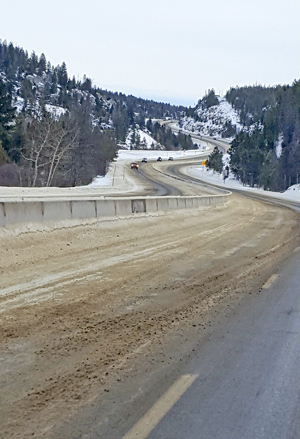
For truckers this is a brake-management and traction chokepoint between Butte and Bozeman. The east side drops at a 6 percent grade, with a posted 25-mph truck limit that holds for roughly four miles down the hill. Warning signs flag the grade and the S-curves before you reach them. Get your speed and your gear set at the top, because the curves and the worst crash stretch come fast on the way down.

  • Highest point on all of Interstate 90, which runs about 3,020 miles from Boston to Seattle (Wikipedia; dangerousroads.org)
  • MDT's road weather station 267008 at I-90 MP 233 lists the elevation as 6,385 feet (MDT RWIS station page); other sources range from 6,329 to 6,410 feet
  • Eastbound descent reaches a 6 percent grade (Montana Standard / Helena IR / montanarightnow coverage)
  • Posted 25-mph truck limit for vehicles 12,000 lb and over holds for about 4 miles down the grade (Montana Standard / Helena IR / montanarightnow coverage)
  • Designated chain-up area on I-90 covers MM 228 to 241 in both directions (MDT Tire and Chain Laws page)
  • Gravel runaway-truck ramp sits at roughly MM 238 to 239 (Flickr grade-warning caption; speed-limit coverage)
  • Worst crash stretch is the S-curves between MM 236 and 238 (Montana Standard / Helena IR / montanarightnow coverage)
02 Chain controls & closures

Montana does not run a tiered chain system. There is no R-1, R-2, or R-3 here. It is binary: MDT either calls for chains in a designated area or it does not, and the call goes out when dangerous or unsafe conditions require it. Homestake Pass is a designated chain-up area on I-90 from MM 228 to 241, both directions. When chains are required, every towing unit must put chains on the drive wheels of one axle. Between October 1 and April 30, towing units of 26,001 lb GVW or greater have to at least carry chains or approved traction devices when in areas where chains may be required (4WD vehicles are exempt, and AutoSocks count as an approved alternative). Studded tires are allowed October 1 through May 31. There is no scheduled seasonal closure of the pass. It stays open year-round, and any shutdown is unplanned and weather or crash driven, usually brief. Chain calls show up late too: on April 24, 2026, MDT required chains for towing units with the road snow-covered (NBC Montana).

03 Notable hazards
Hazard

Steep 6 percent grade with a runaway ramp

The eastbound descent hits a 6 percent grade. There is a gravel runaway-truck ramp at roughly MM 238 to 239 at the bottom of the hill. If your brakes are fading by the time you reach it, that ramp is there for a reason.

Hazard

S-curves at the worst crash stretch

The roughly two-mile stretch between MM 236 and 238 runs through S-curves with reduced advisory speeds, yellow signs, and flashing yellow lights. It logged the most crashes and citations on the pass, which is why the 25-mph truck limit got posted.

Hazard

Ice and spun-out trucks

Frost and ice routinely cost semis their traction here. The April 18 to 19, 2023 closure happened because multiple trucks spun out on ice near MM 232 and blocked both eastbound lanes (NBC Montana).

Hazard

Wind and surface icing at the Divide

MDT's RWIS station 267008 at MP 233 actively monitors wind speed and gusts along with pavement temperature, ice percentage, and surface water. That tells you wind and surface icing are watched conditions right at the summit (MDT RWIS station page).

Hazard

Crash risk in any season

Trouble here is not just a winter thing. On May 30, 2025 a 67-year-old motorcyclist from Anaconda died in a collision with a pickup on westbound I-90 near the pass, and westbound traffic backed up over the pass for a few hours. The cause was vehicle positioning, not weather (NBC Montana).

04 History

The railroad came first. The Northern Pacific Railway completed its line over the area in 1889, running Logan to Garrison by way of Butte. The freeway came much later. The I-90 crossing over Homestake Pass opened in August 1966 after about two years of construction, and it was the second section of the Interstate Highway System to cross the Continental Divide.

The rail line did not last. Its steep grades and tight curvature, over 2.2 percent, made it unsuitable for modern through freight, and it went inactive in 1983. In recent years the pass has built a record of winter shutdowns and a documented state push to slow traffic down. MDT and state officials proposed dropping the car limit from 75 to 65 mph over about ten miles and reviewing the 25-mph truck limit, because the MM 236 to 238 S-curve stretch piled up the most crashes and citations (NBC Montana closure stories; Montana Standard / Helena IR / montanarightnow coverage).

05 FAQ
Are chains required over Homestake Pass?
Only when MDT calls for them. When the call goes out, every towing unit has to chain the drive wheels of one axle, and the designated area is I-90 MM 228 to 241 in both directions. Separately, from October 1 to April 30, heavy towing units of 26,001 lb GVW or greater must at least carry chains or approved traction devices in areas where chains may be required. AutoSocks are an approved alternative, and 4WD vehicles are exempt from the carry rule.
How steep is the grade for trucks?
The eastbound descent reaches 6 percent. There is a 25-mph truck limit for vehicles 12,000 lb and over that holds for about four miles down the grade. Set your speed and pick your gear before you crest the top, not partway down.
Is there a runaway truck ramp on Homestake Pass?
Yes. There is a gravel runaway-truck ramp around MM 238 to 239, near the bottom of the steep eastbound grade.
How high is the pass, and why does weather hit so hard there?
It is the highest point on all of I-90. MDT's summit weather station at MP 233 lists 6,385 feet, and other sources put it anywhere from 6,329 to 6,410. At that altitude on the Continental Divide, snow, ice, and wind stick around well into spring, which is why a late-April chain call here is not unusual.
Does the pass close in winter?
There is no scheduled closure. It stays open year-round, but it can shut briefly and without much warning for ice and crashes. As an example, I-90 closed MM 229 to 234 on April 18 to 19, 2023 after semis spun out on ice. There is no fixed published closure threshold and no reliable annual closure-days count, so do not expect a set date or number.
Where do trucks crash most?
The roughly two-mile S-curve stretch between MM 236 and 238, marked with flashing yellow advisory-speed signs, has logged the most crashes and citations. The 25-mph truck limit was posted to cut down on wrecks there.
06 Related routes

Homestake Pass on the live map

See conditions, incidents, and weather around Homestake Pass in real time.

Open Live Map