← All Interstates
Interstate No. 90 73 live incidents

I-90: The Northern Tier Transcontinental

Interstate 90 is the longest interstate highway in the United States, running 3,020 miles from Seattle, Washington to Boston, Massachusetts. It is the main northern transcontinental route, running parallel to I-94 across Montana and the upper Midwest, then becoming the principal …

73Incidents
20Alerts in its states
13States
4Passes
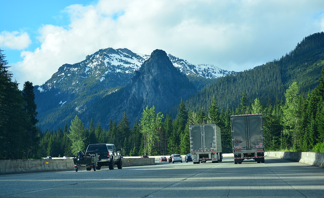
I-90 westbound through Snoqualmie Pass, Washington, with Guye Peak ahead
I-90 westbound through Snoqualmie Pass, Washington, with Guye Peak ahead Joe Mabel / Wikimedia Commons · CC BY-SA 4.0
01 Route overview

Interstate 90 is the longest interstate highway in the United States, running 3,020 miles from Seattle, Washington to Boston, Massachusetts. It is the main northern transcontinental route, running parallel to I-94 across Montana and the upper Midwest, then becoming the principal east-west corridor through the Great Lakes states and the Berkshires.

The geography is varied. From Seattle, I-90 climbs over Snoqualmie Pass (3,022 ft), the main freight route across the Cascades and Washington's only interstate-grade, year-round Cascade crossing (WSDOT), then crosses the Columbia Plateau, climbs the Bitterroot Mountains at Lookout Pass (4,711 ft) on the Idaho-Montana border, threads the Bozeman Pass and the Crow Indian Reservation, rolls across the Great Plains of Wyoming and South Dakota (with a brief brush past the Badlands), passes through Minnesota, and meets up with I-94 in Wisconsin. From Chicago east, I-90 follows the Indiana Toll Road, the Ohio Turnpike, and the Pennsylvania Turnpike to the New York Thruway, which carries it through Buffalo, Syracuse, Utica, and Albany, before becoming the Massachusetts Turnpike to Boston.

For freight, I-90 is the principal route between the Pacific Northwest ports and the Great Lakes industrial belt. It is also one of the most heavily-tolled interstates. Virtually every mile east of Chicago is a toll road. Winter conditions across the western half are severe; Snoqualmie Pass closes repeatedly for avalanche control and crashes, and the Wyoming and South Dakota stretches see frequent ground-blizzard closures.

  • Longest US interstate at 3,020 miles
  • Crosses thirteen states: WA, ID, MT, WY, SD, MN, WI, IL, IN, OH, PA, NY, MA
  • Concurrent with I-94 across most of southern Wisconsin and northern Illinois
  • Tolled across IN, OH, PA, NY, and MA, among the most-tolled interstate corridors
  • Snoqualmie Pass (3,022 ft) is the main freight route over the Cascades, about 28,000 vehicles a day, roughly 5,600 of them freight (WSDOT)
  • Highest point: Beartooth area in Montana / Bozeman Pass at 5,712 ft
  • Crosses the Mississippi River at La Crosse, WI
02 Key cities & junctions
StateMileCity / Junction
WA MM 0 Seattle (I-5 jct)
WA MM 52 Snoqualmie Pass
WA MM 110 Ellensburg
WA MM 220 Spokane (US-395 jct)
ID MM 12 Coeur d'Alene
ID MM 70 Lookout Pass / MT border
MT MM 22 Saint Regis
MT MM 109 Missoula
MT MM 211 Butte (I-15 jct)
MT MM 309 Bozeman
MT MM 401 Billings
WY MM 23 Sheridan
WY MM 207 Buffalo (I-25 jct)
WY MM 207 Gillette
SD MM 17 Spearfish
SD MM 60 Rapid City
SD MM 131 Wall (Badlands access)
SD MM 264 Mitchell
SD MM 357 Sioux Falls (I-29 jct)
MN MM 90 Albert Lea (I-35 jct)
WI MM 14 La Crosse
WI MM 87 Tomah (I-94 jct)
WI MM 180 Madison (I-39 jct)
IL MM 1 South Beloit
IL MM 65 Rockford
IL MM 76 Chicago (I-94/I-294 jct)
IN MM 21 Gary (Indiana Toll Road)
OH MM 49 Toledo (I-75 jct)
OH MM 161 Cleveland (I-77/I-71 jct)
PA MM 1 Erie
NY MM 49 Buffalo (I-190 jct)
NY MM 282 Syracuse (I-81 jct)
NY MM 374 Utica
NY MM 458 Albany (I-87 jct)
MA MM 1 West Stockbridge / Berkshires
MA MM 134 Boston (terminus at Logan)
03 Mountain passes & summits

All US mountain pass conditions →

04 Notable hazards & trouble spots
Hazard

Main Cascade freight route, prone to winter closures

Snoqualmie Pass, WA (MM 47-66)

I-90 climbs to 3,022 ft over Snoqualmie Pass, the only year-round Cascade crossing for commercial vehicles. WSDOT closes the pass repeatedly each winter for avalanche control and crashes; the most persistent avalanche zone is on the west side of the pass, and active-control closures typically run from about 30 minutes to two hours but can last longer in severe conditions (WSDOT). Chain laws are active November through March; truck-only chain stations are at the eastbound (Easton) and westbound (Hyak) approaches.

Hazard

Steep Bitterroot crossing with chain controls

Lookout Pass, ID/MT (MM 65 ID - 0 MT)

Lookout Pass at 4,711 ft is a 6% sustained grade with frequent chain controls. ITD and MDT both close the pass during heavy snow events. The St. Regis runaway-truck ramp on the Montana side sees regular use.

Hazard

Ground blizzards and high-wind closures

Wyoming / South Dakota plains (MM 207 WY - 264 SD)

The 400-mile stretch from Buffalo, WY through Rapid City and Wall, SD is exposed to severe winter winds and ground blizzards that produce zero-visibility whiteouts in minutes. WYDOT and SDDOT close I-90 segments multiple times each winter, sometimes for days.

Hazard

Toll segment with HAZMAT routing requirements

Chicago Skyway / Indiana Toll Road (MM 76 IL - 156 IN)

The Chicago Skyway and Indiana Toll Road carry I-90 around the south side of Chicago and across northern Indiana. Tolls are heavy for commercial vehicles. HAZMAT routing requirements apply; check ISP and ITRCC bulletins.

Hazard

Steep, exposed Berkshire crossing

Berkshire grades, MA (MM 1-50)

The Massachusetts Turnpike climb from the New York line over the Berkshires hits 1,724 ft at Jacob's Ladder. Sustained 5% grades with frequent winter ice events. Trucks routinely shut down at Lee or Stockbridge in major storms.

4a Passes and chain laws on this route

The passes on Interstate 90 with a full guide: grade, chain-control season, closures and hazards. The status is the state DOT's latest reading.

Chain rules for the states these passes are in, and for every state on the route that has a chain law:

All US mountain pass conditions →

05 Active incidents (73)
CONSTRUCTION MT

Road Work

I-90

CONSTRUCTION MT

Road Work

I-90

CONSTRUCTION MT

Road Work

I-90

CONSTRUCTION MT

Road Work

I-90

CONSTRUCTION MN

Work Zone on I-90

I-90

CONSTRUCTION MN

Work Zone on I-90

I-90

CONSTRUCTION MN

Work Zone on I-90

I-90

CONSTRUCTION MN

Work Zone on I-90

I-90

CONSTRUCTION MN

Work Zone on I-90

I-90

CONSTRUCTION MN

Work Zone on I-90

I-90

CONSTRUCTION OH

I-490 eastbound between I-90 and I-77

I-490 eastbound between I-90 and I-77

CONSTRUCTION OH

I-90 in Lake County westbound.

I-90 in Lake County

CONSTRUCTION OH

I-90 in Lake County eastbound.

I-90 in Lake County

CONSTRUCTION OH

I-90 EB between Wagar Rd. and W.73rd St. eastbound.

I-90 between Wagar Rd. and W. 73rd St.

CONSTRUCTION OH

I-90 under King Memorial Rd. eastbound.

I-90 under King Memorial Rd.

CONSTRUCTION OH

I-90 under King Memorial Rd. westbound.

I-90 under King Memorial Rd.

CONSTRUCTION OH

Berea Rd. under I-90 southbound.

Berea Rd. under I-90

CONSTRUCTION OH

Berea Rd. under I-90 northbound.

Berea Rd. under I-90

Showing 18 of 73. View all on map →

06 Weather alerts in its states (20)

National Weather Service alerts in force in the states Interstate 90 runs through. Each one covers a county or a forecast zone, which may be far from the Interstate.

  • 1 alert in Montana: Special Weather Statement
  • 12 alerts in New York: Coastal Flood Warning, High Wind Warning, Wind Advisory
  • 8 alerts in Massachusetts: Coastal Flood Advisory, Coastal Flood Warning, Flood Watch, High Wind Warning, Wind Advisory

See where each alert is on the live map →

07 FAQ
How long does it take to drive I-90 end to end?
A passenger car can cover the 3,020 miles in 45-50 hours of driving time. Commercial drivers respecting hours-of-service rules typically need 6 to 7 days, allowing for a 34-hour reset and the inevitable winter closures across the Cascades, Rockies, and Plains.
Is I-90 a toll road?
Mostly east of Chicago, yes. The Chicago Skyway, Indiana Toll Road, Ohio Turnpike, Pennsylvania Turnpike, New York Thruway, and Massachusetts Turnpike all charge tolls, heavy ones for commercial vehicles. The roughly 2,000 miles between Seattle and Chicago are toll-free.
Does I-90 close in winter?
Frequently. Snoqualmie Pass closes repeatedly each winter for avalanche control, Lookout Pass and the Wyoming and South Dakota plains see multi-day closures during severe weather, and the Berkshire segment in Massachusetts closes during major storms. Always check WSDOT, ITD, MDT, WYDOT, SDDOT, and the individual turnpike authorities before committing to a long-haul winter run.
What is the highest point on I-90?
I-90 reaches 5,712 ft at Bozeman Pass between Bozeman and Livingston, Montana. The Snoqualmie summit (3,015 ft per Wikipedia) is the highest point on the western half but is much lower than the Montana crossings; it is also the lowest of Washington's three year-round Cascade crossings, below Stevens Pass (US 2) and White Pass (US 12).
What major cities does I-90 connect?
I-90 runs directly through Seattle, Spokane, Coeur d'Alene, Missoula, Butte, Bozeman, Billings, Sioux Falls, Madison, Rockford, Chicago, Toledo, Cleveland, Erie, Buffalo, Syracuse, Albany, and Boston.

Interstate 90 Live Map

See every incident, alert, and road condition on Interstate 90 in real time.

Open Live Map