← All passes
Mountain pass No. 36 No live data

Cabbage Hill (Deadman Pass)

Cabbage Hill is the steep western descent on I-84 where the freeway drops off the Blue Mountains in eastern Oregon. The road climbs and falls between Pendleton at the northwest base and La Grande to the southeast. ODOT's trucker brochure puts the downgrade about 35 miles west of

3,615Elevation (ft)
1,102Metres
I-84Route
ORState
Interstate 84 climbs eastbound up Cabbage Hill toward Deadman Pass in the Blue Mountains of northeastern Oregon.
Interstate 84 climbs eastbound up Cabbage Hill toward Deadman Pass in the Blue Mountains of northeastern Oregon.SydneyNSWAus / Wikimedia Commons · CC BY-SA
00 Live conditions
No live data
No live condition feed for this pass right now. Check the state DOT or 511 before you climb.
01 Overview

Cabbage Hill is the steep western descent on I-84 where the freeway drops off the Blue Mountains in eastern Oregon. The road climbs and falls between Pendleton at the northwest base and La Grande to the southeast. ODOT's trucker brochure puts the downgrade about 35 miles west of La Grande. The official name is Emigrant Hill, drivers call it Cabbage Hill, and the wider area carries the name Deadman Pass.

Westbound is the side that gets respect. ODOT describes a seven-mile downgrade where you lose about 2,000 feet of elevation in six miles and twist through a double hairpin turn at a 6-percent downgrade. The signed grade runs from Milepost 227 down to Milepost 217. Going east, I-84 climbs roughly 3,000 feet up a series of switchbacks with a maximum grade of 5 to 6 percent, per the sourced Wikipedia article on Interstate 84 in Oregon. The lanes are split by a wide median for about eight miles through the steep section.

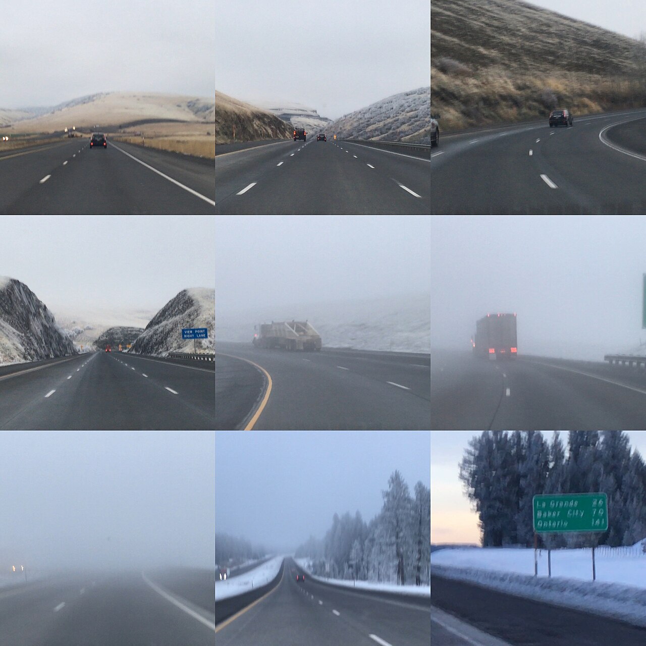
Truckers care because the combination is hard to manage: a sustained 6-percent grade, two hairpins, and weather that turns fast. ODOT calls it some of the most changeable and severe weather in the Northwest, with fog, snow, and black ice common from October through April. The hill has a long crash record, and ODOT's own numbers show out-of-state carriers and brake problems show up again and again. It is widely regarded as one of the most hazardous truck descents in the Pacific Northwest.

  • Westbound downgrade runs Milepost 227 to Milepost 217, signed as a seven-mile, 6-percent grade (ODOT brochure)
  • You drop about 2,000 feet in six miles and pass through a double hairpin turn (ODOT brochure)
  • Eastbound, I-84 climbs roughly 3,000 feet on switchbacks at a max grade of 5 to 6 percent (Wikipedia, Interstate 84 in Oregon)
  • Two runaway truck escape ramps sit at Milepost 221.97 and Milepost 220.11 (ODOT brochure)
  • On average 78 percent of Cabbage Hill crashes involve out-of-state motor carriers (ODOT brochure)
  • On average 59 percent of brake problems contribute to accidents on the hill (ODOT brochure)
  • Fog, snow, and black ice are common between October and April (ODOT brochure)
02 Chain controls & closures

There is no fixed chain-control calendar published for this hill. Oregon runs sign-activated restrictions, not a set season. ODOT law requires you carry and use tire chains when conditions warrant or signs are posted, and the brochure flags fog, snow, and black ice as common from October through April. That October-to-April window is the practical chain season here, but the trigger is the sign and the weather, not a date. When ODOT activates the restriction, chains or traction tires are required where signs direct. Traction tires can stand in for chains only on vehicles rated 10,000 lb GVW or less that are not towing; disobeying the signs is a Class C traffic infraction. The chain-up area is at Milepost 217, near the bottom toward Pendleton. The restriction comes off when conditions clear and ODOT pulls the signs. Check ODOT TripCheck for the live status before you run it.

03 Notable hazards
Hazard

Sustained 6-percent grade with a double hairpin

The westbound downgrade runs seven miles, dropping about 2,000 feet in six miles, and twists through a double hairpin turn at 6 percent (ODOT brochure). Pick your gear before the top and stay off the brakes as much as you can. The two escape ramps at Milepost 221.97 and Milepost 220.11 are there because trucks have needed them.

Hazard

Brake failure

ODOT reports that on average 59 percent of brake problems contribute to accidents on the hill. There is a brake-test area at the weigh station at Milepost 227, with a three-quarter-mile advance sign, followed by a sign reading LAST WARNING 6 MILES / 6% DOWNGRADE AHEAD. Check your brakes before you start down.

Hazard

Fog and black ice

Fog, snow, and black ice are common between October and April (ODOT brochure). Dense fog has driven visibility under 100 feet and triggered multi-vehicle crashes, including the February 2014 event. You can lose the road in front of you with little warning.

Hazard

Severe, changeable weather

ODOT calls this some of the most changeable and severe weather in the Northwest. The National Weather Service Pendleton office issues Winter Weather Advisories and Winter Storm Warnings for the Northern and Southern Blue Mountains around Meacham and Tollgate, the corridor the hill sits in. Conditions at the top can differ from the base.

Hazard

Out-of-state carrier crash pattern

On average 78 percent of Cabbage Hill crashes involve out-of-state motor carriers (ODOT brochure). If this is your first run down the hill, treat the posted truck speeds and the brake check as the floor of what you do, not the ceiling.

04 History

The name Deadman Pass goes back to the 1870s, the Bannock War era, and the killings of travelers and teamsters during conflict with the Bannock and Paiute. Sources disagree on the exact year, with one pointing to 1876 and broader accounts tying it to the 1878 Bannock War, so the safe read is the late 1870s. The pass has kept the name through a long run of modern crashes on the same grade.

The worst recent one came on December 30, 2012, when a tour bus carrying about 40 passengers from Las Vegas toward British Columbia broke through a guardrail on icy I-84 about 15 miles east of Pendleton near Deadman Pass, around 10:30 a.m. Nine people died and more than 26 were hospitalized, and it is often cited as the deadliest crash in the area. In February 2014, heavy fog dropped visibility to near zero and set off a string of wrecks, including a Monday-night pileup of about 16 vehicles, 9 of them semis, between Meacham and Cabbage Hill. ODOT closed the freeway on the Tuesday and Wednesday nights when visibility fell below 100 feet. Then on February 21, 2022, a snow-and-ice chain reaction in the early afternoon involved as many as 98 vehicles per Oregon State Police, closing I-84 between Pendleton and La Grande until the next day.

05 FAQ
How steep is Cabbage Hill and how long is the descent?
Westbound it is a 6-percent downgrade signed for about seven miles. You lose roughly 2,000 feet of elevation in six miles and go through a double hairpin turn. The graded section runs from Milepost 227 down to Milepost 217 (ODOT brochure).
Where do I do my brake check before going down?
At the weigh station brake-test area at Milepost 227. There is a three-quarter-mile advance sign for it, and after it you will see the LAST WARNING 6 MILES / 6% DOWNGRADE AHEAD sign. Do the check before you commit to the grade (ODOT brochure).
Where are the runaway truck ramps?
There are two escape ramps on the descent, at Milepost 221.97 and Milepost 220.11. The brochure signs them at Milepost 221 and Milepost 220 (ODOT brochure).
Where do I chain up, and do I have to carry chains?
The chain-up area is at Milepost 217, near the bottom toward Pendleton. Oregon law requires you carry and use chains when conditions warrant or signs are posted, and fog, snow, and black ice are common October through April. Traction tires can substitute for chains only on vehicles rated 10,000 lb GVW or less that are not towing (ODOT brochure; ODOT Chain Law page).
When does the hill close, and is there a set rule?
There is no fixed published threshold. ODOT closes it case by case for weather and crashes. As an example, during the February 2014 fog event it closed the freeway at night when visibility dropped below 100 feet, then reopened when conditions improved. Check ODOT TripCheck before you run it (ODOT bulletin; ODOT brochure).
What is the safe descent speed for a loaded truck?
ODOT posts truck speeds that drop as weight goes up. The brochure's example table for 5-plus axle trucks: 50,000 to 65,000 lb at 37 mph; 65,000 to 70,000 at 26; 70,000 to 75,000 at 22; and 75,000 to 80,000 at 18 mph. Those are maximums in good weather. Bad weather means slower (ODOT brochure).
06 Related routes

Cabbage Hill (Deadman Pass) on the live map

See conditions, incidents, and weather around Cabbage Hill (Deadman Pass) in real time.

Open Live Map