← All Interstates
Interstate No. 84 94 live incidents

I-84: The Oregon Trail / Hartford Pike

Interstate 84 is an unusual interstate: it consists of two non-contiguous segments. The western segment runs 770 miles from Portland, Oregon to Echo Junction, Utah (where it terminates at I-80). The eastern segment runs 233 miles from Dunmore, Pennsylvania across New York and Con…

94Incidents
21Alerts in its states
7States
6Passes
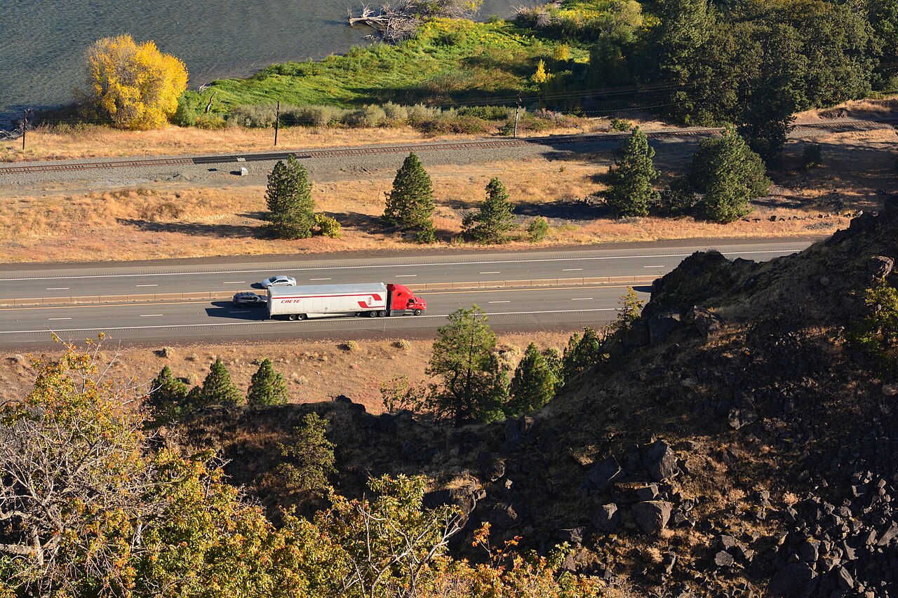
I-84 through the Columbia River Gorge, seen from Rowena Crest Viewpoint, Oregon
I-84 through the Columbia River Gorge, seen from Rowena Crest Viewpoint, Oregon Joe Mabel / Wikimedia Commons · CC BY-SA 4.0
01 Route overview

Interstate 84 is an unusual interstate: it consists of two non-contiguous segments. The western segment runs 770 miles from Portland, Oregon to Echo Junction, Utah (where it terminates at I-80). The eastern segment runs 233 miles from Dunmore, Pennsylvania across New York and Connecticut to Sturbridge, Massachusetts (where it terminates at I-90). The two segments are not connected and serve completely different regions.

For freight, the western I-84 is the principal alternative to I-90 for Pacific Northwest traffic moving inland, particularly for produce and lumber from the Columbia Basin and the Snake River plain. It traces the route of the Oregon Trail and is the only interstate connection between Portland and the Salt Lake City freight hub. The eastern I-84 is a short connector linking the I-80 corridor in Pennsylvania to Boston via Hartford.

Geographically the western segment includes some of the most challenging interstate terrain in the country: the Columbia River Gorge (with severe crosswinds and ice events), Cabbage Hill / Deadman Pass in Oregon (a sustained 6% grade), the Blue Mountains, and the Snake River Canyon. The eastern segment is mostly rolling New England terrain.

  • Two non-contiguous segments: western (OR-ID-UT) and eastern (PA-NY-CT-MA)
  • Western segment follows the historic Oregon Trail
  • Includes Cabbage Hill / Deadman Pass (OR), one of the steepest interstate grades
  • Crosses the Columbia River Gorge with severe crosswind exposure
  • Eastern segment connects I-80 in PA to I-90 in MA via Hartford
  • Western segment is toll-free; eastern is mostly toll-free
  • Combined length of both segments: approximately 1,000 miles
02 Key cities & junctions
StateMileCity / Junction
OR MM 0 Portland (I-5 jct)
OR MM 64 Hood River / Columbia Gorge
OR MM 84 The Dalles
OR MM 188 Pendleton
OR MM 218 Cabbage Hill / Deadman Pass
OR MM 261 La Grande
OR MM 374 Ontario / ID line
ID MM 28 Caldwell
ID MM 53 Boise
ID MM 173 Twin Falls
ID MM 245 Burley
ID MM 285 Pocatello area / I-86 jct
ID MM 401 Snowville line / UT border
UT MM 41 Tremonton (I-15 jct)
UT MM 95 Echo Junction (I-80 jct)
PA MM 1 Dunmore / Scranton (I-81 jct)
PA MM 53 Matamoras / Port Jervis
NY MM 8 Middletown
NY MM 60 Newburgh (I-87 jct)
NY MM 71 Fishkill
CT MM 19 Danbury (I-684 access)
CT MM 42 Waterbury
CT MM 56 Hartford (I-91 jct)
CT MM 90 Putnam
MA MM 12 Sturbridge (I-90 jct)
03 Mountain passes & summits
NO REPORT N/A

Blue Mountain Summit (I-84)

No report since 2026-04-16

Pass conditions & guide →
NO REPORT N/A

Cabbage Hill (I-84)

No report since 2026-04-17

Pass conditions & guide →
NO REPORT N/A

Deadman Pass (I-84)

No report since 2026-04-16

OPEN 68°F

I-84 Rattlesnake Pass

Dry · 68°F, wind 8 mph W

NB · No restrictions
SB · No restrictions

OPEN 69°F

I-84 Whites Valley

Dry · 69°F, wind 5 mph E

NB · No restrictions
SB · No restrictions

OPEN N/A

Sweetzer (I-84)

No data

NB · No restrictions
SB · No restrictions

All US mountain pass conditions →

04 Notable hazards & trouble spots
Hazard

One of the steepest sustained interstate grades

Cabbage Hill / Deadman Pass, OR (MM 215-228)

Westbound I-84 descends 2,000 ft over 6 miles on a sustained 6% grade with 55 mph truck speed limit. Brake fires are routine; runaway-truck ramps see frequent use. ODOT operates a mandatory truck brake-check area at Deadman Pass summit. Engine brake aggressively and stay below the posted limit.

Hazard

Severe crosswinds and winter ice

Columbia River Gorge, OR/WA (MM 17-84)

The 67-mile Gorge segment is exposed to sustained crosswinds of 60-80 mph in fall and winter, with frequent ice events in the colder months. ODOT closes the Gorge multiple times each winter; the alternate via Bend adds 200+ miles.

Hazard

Mountainous segment with chronic winter closures

Blue Mountains / Snake River Canyon, OR/ID (MM 261 OR - 53 ID)

I-84 across the Blue Mountains and the Snake River Canyon includes sustained climbs and exposed canyon segments. ODOT and ITD close segments regularly in winter. Plan fuel and parking before La Grande eastbound or Boise westbound.

Hazard

Sustained crosswinds across open terrain

Snake River plain crosswinds, ID (MM 53-285)

The 230-mile segment between Boise and Pocatello is flat and exposed. Sustained winds of 40-60 mph push high-profile trailers. ITD issues high-profile vehicle advisories regularly.

Hazard

Chronic urban congestion

Hartford / Waterbury congestion, CT (MM 42-56)

Eastern I-84 through central Connecticut carries heavy commuter and freight traffic and backs up daily through central Connecticut. The Waterbury "Mixmaster" interchange (I-84/Route 8) is particularly incident-prone. CTDOT publishes real-time alerts.

4a Passes and chain laws on this route

The passes on Interstate 84 with a full guide: grade, chain-control season, closures and hazards. The status is the state DOT's latest reading.

Chain rules for the states these passes are in, and for every state on the route that has a chain law:

All US mountain pass conditions →

05 Active incidents (94)
CONSTRUCTION NY

roadwork

I-84

CONSTRUCTION NY

roadwork

I-84

CONSTRUCTION NY

roadwork

I-84

CONSTRUCTION NY

roadwork

I-84

CONSTRUCTION NY

roadwork

I-84

CONSTRUCTION NY

roadwork

I-84

CONSTRUCTION PA

ROADWORK on I-84 Eastbound At MM 43. Left Lane (of 2 Lanes) Blocked, Left Shoulder Blocked.

I-84

CONSTRUCTION PA

ROADWORK on I-84 Westbound between MM 46 and MM 43. Left Lane (of 2 Lanes) Blocked, Left Shoulder Blocked.

I-84

CONSTRUCTION UT

roadwork

I-84

CONSTRUCTION ID

Minor Road maintenance on I-84 Eastbound from N Overland Ave to S 200 W. 9/22/2026 8:00 AM MT to 9/26/2026 7:0…

I-84

CONSTRUCTION ID

Minor Road maintenance on I-84 Eastbound from MM (65) to MM (67). 1 Right lane closed. 9/28/2026 10:00 PM MT t…

I-84

CONSTRUCTION ID

Work on underground services on I-84-BL Both Directions from N Middleton Rd to SH-55. 1 Left lane closed. 9/21…

I-84-BL

CONSTRUCTION ID

Work on underground services on I-84-BL Both Directions from N Middleton Rd to SH-55. 1 Left lane closed. 9/21…

I-84-BL

CONSTRUCTION ID

Long term road construction on I-84 Eastbound from Centennial Way to Franklin Rd. 11/3/2023 12:00 AM MT to 5/2…

I-84

CONSTRUCTION ID

Long term road construction on I-84 Westbound from Franklin IC to Centennial IC. All Lanes Affected. 11/3/2023…

I-84

CONSTRUCTION ID

Road construction on ramp from I-84-BL Eastbound to I-84 Westbound. 9/9/2026 12:27 PM MT to 11/28/2026 5:00 PM…

I-84-BL Eastbound

CONSTRUCTION ID

Road construction on ramp from I-84 Westbound to I-84-BL Eastbound. 9/9/2026 12:27 PM MT to 11/28/2026 5:00 PM…

I-84 Westbound

CONSTRUCTION ID

Planned roadwork on ramp from I-84-BL Eastbound to I-84 Eastbound. 3/20/2026 12:51 PM to 5/22/2027 12:52 PM Mo…

I-84-BL Eastbound

Showing 18 of 94. View all on map →

06 Weather alerts in its states (21)

National Weather Service alerts in force in the states Interstate 84 runs through. Each one covers a county or a forecast zone, which may be far from the Interstate.

  • 1 alert in Utah: Hydrologic Outlook
  • 12 alerts in New York: Coastal Flood Warning, High Wind Warning, Wind Advisory
  • 5 alerts in Connecticut: Coastal Flood Advisory, Coastal Flood Warning, High Wind Warning, Wind Advisory
  • 8 alerts in Massachusetts: Coastal Flood Advisory, Coastal Flood Warning, Flood Watch, High Wind Warning, Wind Advisory

See where each alert is on the live map →

07 FAQ
Why are there two separate I-84 segments?
The two I-84 segments (western OR-ID-UT and eastern PA-NY-CT-MA) were designated separately and have never been connected by interstate-grade roadway. They serve completely different regions. There is no plan to connect them.
Is I-84 a toll road?
The western segment is entirely toll-free. The eastern segment is mostly toll-free except for occasional bridge tolls in the New York / Connecticut area.
Does I-84 close in winter?
Frequently on the western segment. Cabbage Hill, the Columbia River Gorge, the Blue Mountains, and the Snake River plain all see multi-day closures. ODOT, ITD, and UDOT publish real-time status.
How steep is Cabbage Hill?
Cabbage Hill / Deadman Pass on westbound I-84 in Oregon is a sustained 6% downgrade for about 6 miles, dropping over 2,000 ft. It is among the steepest sustained interstate grades in the country. ODOT requires a mandatory truck brake check at the summit and posts a 55 mph truck speed limit.
What major cities does I-84 connect?
The western segment serves Portland, The Dalles, Pendleton, La Grande, Boise, Twin Falls, and connects to I-80 at Echo Junction. The eastern segment serves Scranton, Newburgh, Danbury, Waterbury, Hartford, and ends at I-90 in Sturbridge.

Interstate 84 Live Map

See every incident, alert, and road condition on Interstate 84 in real time.

Open Live Map