← All passes
Mountain pass No. 17 No live data

Sideling Hill

First, a correction worth knowing before you plan a trip. Sideling Hill in Maryland is not on I-70. The road that cuts through it is I-68, the National Freeway, along with old US 40. At Hancock, Maryland, I-70 turns north toward Breezewood and the Pennsylvania Turnpike. I-68 bran

1,765Elevation (ft)
538Metres
I-68Route
MDState
Interstate 68 sweeps through the Sideling Hill road cut near Hancock, Maryland, where the highway slices through the exposed folded rock of the ridge.
Interstate 68 sweeps through the Sideling Hill road cut near Hancock, Maryland, where the highway slices through the exposed folded rock of the ridge.Analogue Kid / Wikimedia Commons · CC BY 2.5
00 Live conditions
No live data
No live condition feed for this pass right now. Check the state DOT or 511 before you climb.
01 Overview

First, a correction worth knowing before you plan a trip. Sideling Hill in Maryland is not on I-70. The road that cuts through it is I-68, the National Freeway, along with old US 40. At Hancock, Maryland, I-70 turns north toward Breezewood and the Pennsylvania Turnpike. I-68 branches west and crosses Sideling Hill about 5 to 6 miles past Hancock (Wikipedia; AARoads). If someone tells you Sideling Hill is an I-70 climb, they have the wrong ridge.

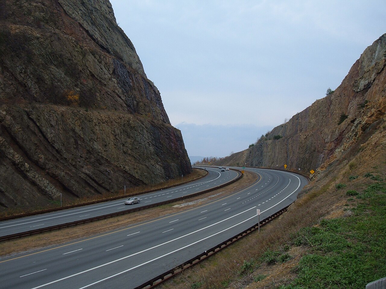
What makes this spot famous is the road cut, a notch blasted 340 feet deep through the crest of the ridge. The ridge surface at the cut sits around 1,620 feet; the road runs through at about 1,280 feet (Maryland Geological Survey, Fact Sheet 17). The cut is 200 feet wide at road level and opens to 720 feet wide at the top. Drivers know it as a landmark first and a grade second, because the cut replaced the old steep climb that the National Road used to make over the top.

The crossing connects Hancock and the I-70/I-68 junction westward toward Cumberland and the Allegheny region of western Maryland (AARoads; Wikipedia). It stays open year-round. There is no scheduled winter shutdown here; when the road closes it is because of a crash or weather, not a calendar. For a sourced grade percent or the length of the I-68 climb, none was published by MDOT or FHWA, so this guide does not give one. The cut took out much of the old steep approach, which is part of why a hard grade number is hard to pin down.

  • The crossing is on I-68 (the National Freeway) and old US 40, not I-70; at Hancock, MD, I-70 heads north and I-68 branches west (Wikipedia; AARoads)
  • The road cut is 340 ft deep, 200 ft wide at road level and 720 ft wide at the top (Maryland Geological Survey, Fact Sheet 17)
  • Ridge surface at the cut is about 1,620 ft; road level is about 1,280 ft (Maryland Geological Survey, Fact Sheet 17)
  • The ridge's overall high point, Fisher Point, is 2,310 ft, up in Fulton County, PA, away from the highway (Wikipedia)
  • Building the cut took about 2,600 tons of explosives and removed roughly 4.5 million cubic yards of rock, blasted Apr 1983 to Aug 1984 (Maryland Geological Survey, Fact Sheet 17)
  • The project cost about $20.1 million, 90 percent federal and 10 percent state (Maryland Geological Survey, Fact Sheet 17)
  • Maryland has no mandatory tire-chain law and posts no chain-control levels; chains are allowed for safety in snow or ice but not required (Md. Transp. Code 22-405.2)
02 Chain controls & closures

Maryland runs no chain-control season the way the western states do. There is no posted "chains required" level here, nothing like Caltrans R1/R2/R3 or CDOT's system. The statute simply permits tire chains of reasonable proportions on any vehicle when they are needed for safety because of snow, ice, or other conditions that tend to make a vehicle skid (Md. Transp. Code 22-405.2). Chains are allowed, not ordered, so there is no season to open or close. Studded tires are the one thing tied to dates: they are permitted November 1 through March 31, and only for vehicles registered in Allegany, Carroll, Frederick, Garrett, or Washington counties (Md. Transp. Code 22-405.2). Maryland also does not run designated chain-up or brake-check areas with mile markers on I-68 or I-70, so do not expect a numbered pull-off. When the road closes it is incident-driven, from a crash or weather, and Maryland CHART (chart.maryland.gov) tracks the real-time status.

03 Notable hazards
Hazard

Fog and low visibility

Ridge fog is the documented danger on this corridor. In December 2019 a chain-reaction pileup on I-68 hit 58 vehicles across 29 separate crashes in dense fog; westbound lanes closed about four hours and 10 people went to the hospital with non-life-threatening injuries. That pileup was on Big Savage Mountain near Frostburg, west of Sideling Hill, not on Sideling Hill itself, but it shows the ridge-fog pattern these I-68 crossings share (WUSA9; Cumberland Times-News). When the crest is socked in, slow down and leave room.

Hazard

Wind

The exposed ridgetop and the open road cut channel the wind. High-profile rigs and empty trailers are the ones that feel it on Appalachian ridge crossings. No Sideling-Hill-specific wind figure was published, so treat this as a real hazard without a number: watch your trailer in gusts up top.

Hazard

Ice

Ridge crests in western Maryland freeze before the valleys do. The road can be iced at the top while the approach grades are only wet, the standard mountain winter trap. The National Weather Service issues winter weather products for this area, so check the forecast before you climb.

Hazard

Falling rock

The cut faces were built with engineered benches to catch falling rock, 10 to 20 feet wide, slanted back toward the slope, four per side and spaced 80 feet apart vertically (Maryland Geological Survey, Fact Sheet 17). They do their job, but loose rock is part of life next to a 340-foot cut, so do not park or linger at the base of the walls.

04 History

Before the interstate, US 40 and the National Road went over Sideling Hill the hard way, with a steep grade on each side and a sharp hairpin turn at the crest (FHWA Highway History; Wikipedia). It was known for a long time as a steep, dangerous climb. The fix was to cut straight through the ridge instead of going over it.

Excavation of the I-68 road cut began in April 1983. Blasting finished about 16 months later, in August 1984, after roughly 2,600 tons of explosives took out about 4.5 million cubic yards of rock. The prime contractor was Holloway Construction Co. of Wixom, Michigan, and the work cost around $20.1 million, split 90 percent federal and 10 percent state. The highway through the cut opened in August 1985 (all from Maryland Geological Survey, Fact Sheet 17). On August 2, 1991, Gov. William Donald Schaefer dedicated the Sideling Hill Exhibit Center at the cut, which showed off the folded rock layers exposed by the blasting. The center closed in 2009 for budget reasons and the exhibit moved to Hancock (Maryland Geological Survey, Fact Sheet 17; Wikipedia).

05 FAQ
Is Sideling Hill on I-70 or I-68?
It is on I-68, the National Freeway, and old US 40. At Hancock, Maryland, I-70 turns north toward Breezewood and the Pennsylvania Turnpike, while I-68 branches west and crosses Sideling Hill about 5 to 6 miles past Hancock. I-70 does not cross Sideling Hill at all (Wikipedia; AARoads; FHWA).
How high is Sideling Hill where the highway crosses?
The ridge surface at the cut is about 1,620 feet, and the road runs through at about 1,280 feet, which makes the cut 340 feet deep (Maryland Geological Survey, Fact Sheet 17). The ridge's overall high point, Fisher Point at 2,310 feet, is up in Fulton County, Pennsylvania, well away from the road.
Do I need chains on I-68 or I-70 in Maryland in winter?
No. Maryland has no mandatory chain law and posts no chain-control levels. The state allows chains for safety in snow or ice but does not require them. Studded tires are the exception with a date attached: they are allowed November 1 through March 31, and only for vehicles registered in Allegany, Carroll, Frederick, Garrett, or Washington counties (Md. Transp. Code 22-405.2).
What is the main weather danger on this stretch?
Dense ridge fog, plus ice on the crests in winter. A December 2019 fog pileup on I-68 involved 58 vehicles, though that one was on Big Savage Mountain west of here, not Sideling Hill. Check the National Weather Service forecast and Maryland CHART (chart.maryland.gov) before you drive (WUSA9; Cumberland Times-News; Maryland CHART; NWS).
Is there a runaway-truck ramp on Sideling Hill?
Nothing was found that confirms a runaway-truck ramp at the I-68 Sideling Hill cut, so do not count on one being there. The cut took out much of the old steep US 40 climb, but plan your descent on your own brakes and gears regardless.
Why is there a giant rock cut here?
To replace the old steep US 40 hairpin that went over the top of the ridge. Crews blasted through the crest from 1983 to 1985, removing about 4.5 million cubic yards of rock. The cut also exposed a textbook folded syncline, which is why the rock layers there are some of the best exposures in the northeastern U.S. (Maryland Geological Survey; FHWA).
06 Related routes

Sideling Hill on the live map

See conditions, incidents, and weather around Sideling Hill in real time.

Open Live Map