← All Interstates
Interstate No. 5 1 live incident

I-5: The Pacific Coast Spine

Interstate 5 is the only continuous freeway connecting Mexico and Canada through the United States, running 1,381 miles from San Ysidro at the California-Mexico border to Blaine, Washington at the Peace Arch crossing into British Columbia. It is the dominant freight corridor of t…

1Incidents
4Alerts in its states
3States
2Passes
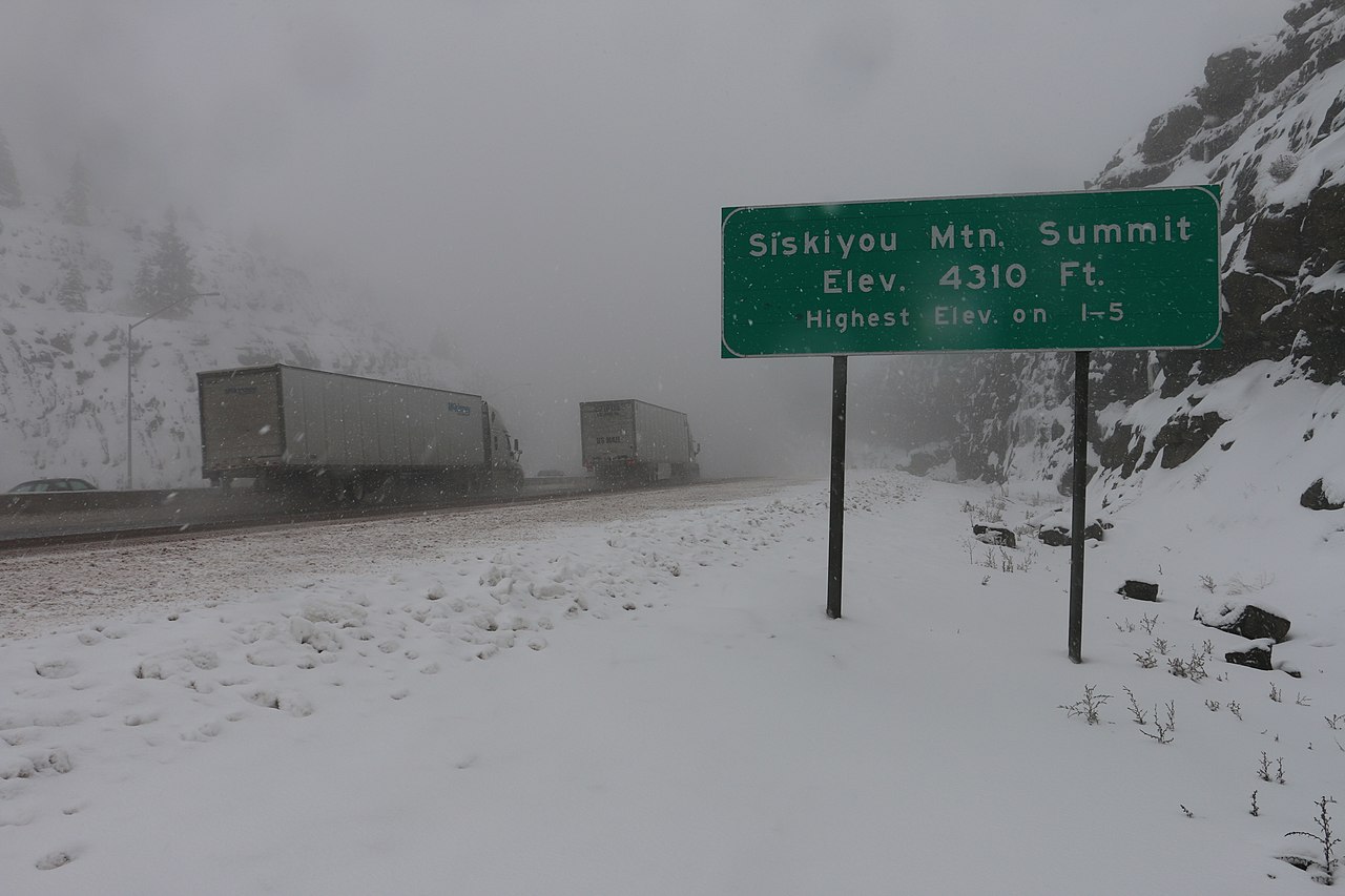
I-5 over Siskiyou Summit (Elev. 4,310 ft, the highest point on I-5), Oregon
I-5 over Siskiyou Summit (Elev. 4,310 ft, the highest point on I-5), Oregon Oregon Department of Transportation / Wikimedia Commons · CC BY 2.0
01 Route overview

Interstate 5 is the only continuous freeway connecting Mexico and Canada through the United States, running 1,381 miles from San Ysidro at the California-Mexico border to Blaine, Washington at the Peace Arch crossing into British Columbia. It is the dominant freight corridor of the West Coast, moving produce out of the San Joaquin Valley, container traffic between the ports of Long Beach, Oakland, and Tacoma, and timber and agricultural products from the Pacific Northwest.

The route splits cleanly into three personalities. From San Diego through Los Angeles and up the western edge of the San Joaquin Valley, I-5 is largely a flat agricultural expressway crossed by the Tejon Pass (Grapevine) at 4,144 ft, a 6% grade that closes for snow several days each winter. Through Northern California it climbs into the Cascades over Siskiyou Summit (4,310 ft), the toughest sustained climb on the entire interstate, before descending into the Rogue Valley of Oregon. From Eugene north through Portland, Olympia, Seattle, and the Skagit Valley, I-5 becomes a dense urban interstate routinely choked with congestion in the four-hour Portland-Seattle-Tacoma chain.

For commercial operators, I-5 carries most of the West Coast's long-haul freight. CHP and Oregon DOT enforce truck-specific speed limits and bridge weight restrictions aggressively, and the Siskiyou-Shasta corridor has a string of staffed weigh and inspection stations on both the California and Oregon sides of the summit. Chain controls are routine November through April from the Grapevine north.

  • Only US interstate that touches both the Mexican and Canadian borders
  • Crosses Siskiyou Summit (4,310 ft) on the California-Oregon line, the highest point on the entire I-5 route (Wikipedia: Interstate 5)
  • Tejon Pass / Grapevine (4,144 ft) closes 5-15 times per winter for snow
  • Carries the bulk of Port of Long Beach and Port of Tacoma container drayage
  • Routes through downtown Sacramento via the I-5 / Capital City Freeway interchange
  • Designated CARB-compliant corridor in California. Pre-2010 trucks face restrictions.
  • Concurrent with no other interstate for any significant distance, runs solo end-to-end
02 Key cities & junctions
StateMileCity / Junction
CA MM 0 San Ysidro / Mexican Border
CA MM 16 San Diego (I-8 jct)
CA MM 110 Santa Ana / Anaheim
CA MM 134 Los Angeles (I-10 jct)
CA MM 207 Tejon Pass / Grapevine Summit
CA MM 295 Bakersfield (CA-58 jct)
CA MM 460 Stockton (I-205/I-580 jct)
CA MM 519 Sacramento (I-80 jct)
CA MM 685 Redding
CA MM 796 Siskiyou Summit (just north)
OR MM 14 Ashland
OR MM 119 Eugene
OR MM 234 Salem
OR MM 308 Portland (I-84 jct)
WA MM 39 Vancouver / Portland metro
WA MM 102 Olympia (US-101 jct)
WA MM 132 Tacoma
WA MM 165 Seattle (I-90 jct)
WA MM 226 Mount Vernon / Skagit Valley
WA MM 274 Blaine / Canadian Border
03 Mountain passes & summits
OPEN N/A

Jct I-5

No data

NB · No chain controls are in effect at this time.
SB · No chain controls are in effect at this time.

NO REPORT N/A

Siskiyou Summit (I-5)

No report since 2026-04-25

Pass conditions & guide →

All US mountain pass conditions →

04 Notable hazards & trouble spots
Hazard

Highest sustained grade on the interstate system

Siskiyou Summit, OR (MM 0-15 just north of CA line)

I-5 climbs to 4,310 ft over a sustained 6% grade between Yreka, CA and Ashland, OR. ODOT closes the summit during heavy snow events 10-20 times per winter. Mandatory chain-up areas are at the Mt. Ashland exit (southbound) and the Henley-Hornbrook area (northbound). Runaway-truck ramps line the Oregon descent. Use them.

Hazard

Sudden snow on a major LA freight artery

Tejon Pass / Grapevine, CA (MM 195-225)

A 6% grade climbing from the San Joaquin Valley over the Tehachapi Mountains. Caltrans closes the Grapevine 5-15 days per winter, severing the only direct truck route between Los Angeles and the Bay Area / Central Valley. There is no practical detour. Drivers either wait at Lebec / Grapevine or reroute via US-395 and the high desert.

Hazard

Long, exposed Cascade climb

Mt. Shasta corridor, CA (MM 720-790)

The 70-mile climb from Redding to the Oregon line gains over 4,000 ft. Black ice forms on the bridges around Lake Shasta in winter, and the Weed area is notorious for crosswinds that push high-profile trailers into the breakdown lane. Caltrans posts chain controls regularly between Dunsmuir and Yreka.

Hazard

Chronic urban congestion and HOV restrictions

Seattle-Tacoma corridor, WA (MM 130-180)

The 50-mile stretch from JBLM through downtown Seattle and into Lynnwood is one of the most congested urban interstates on the West Coast. Truck-restricted express lanes operate reversibly on the I-5 Express south of the Ship Canal Bridge. Plan deliveries outside the 6-9 AM and 3-7 PM peaks.

Hazard

Tule fog blackouts in winter

San Joaquin Valley fog, CA (MM 250-450)

Late-night and early-morning tule fog can drop visibility to under 50 feet between November and February. Tule fog is the leading cause of weather-related crashes in California, and this stretch of I-5 has seen repeated large chain-reaction pileups in it (a 1997 fog crash near Elk Grove involved 25 cars and nine semis; a January 2024 pileup in Kern County involved more than 40 vehicles with visibility down to about 10 feet). Slow well below the posted limit, use four-ways, and pull off at a service plaza if you cannot see the next reflector.

4a Passes and chain laws on this route

The passes on Interstate 5 with a full guide: grade, chain-control season, closures and hazards. The status is the state DOT's latest reading.

Chain rules for the states these passes are in, and for every state on the route that has a chain law:

All US mountain pass conditions →

05 Active incidents (1)
CONSTRUCTION CA

Caltrans : Long-term construction on I-580 Westbound entering at Western Dr (Richmond). On Ramp closed. Expect…

I-580 W

06 Weather alerts in its states (4)

National Weather Service alerts in force in the states Interstate 5 runs through. Each one covers a county or a forecast zone, which may be far from the Interstate.

  • 2 alerts in California: Coastal Flood Advisory, Wind Advisory
  • 2 alerts in Washington: Frost Advisory, Wind Advisory

See where each alert is on the live map →

07 FAQ
How long does it take to drive I-5 from Mexico to Canada?
A passenger car can cover the 1,381 miles in about 22-24 hours of pure driving time. Commercial drivers respecting hours-of-service rules typically need 3 days, with mandatory rest breaks and time spent in the dense urban congestion through the Los Angeles, Portland, and Seattle metros.
Does I-5 close in winter?
Yes, most often at Siskiyou Summit on the Oregon-California border and the Tejon Pass (Grapevine) north of Los Angeles. Both close to all traffic during heavy snow events, sometimes for 12-24 hours at a time. Caltrans, ODOT, and WSDOT publish real-time status.
Are chains required on I-5?
Frequently in winter on Tejon Pass, Mt. Shasta corridor, and Siskiyou Summit. Caltrans posts R-1, R-2, and R-3 chain controls; Oregon requires chains or traction tires whenever signs are active. Commercial vehicles must always carry the legally required number of chains in California chain-control areas from October through April.
What major cities does I-5 connect?
I-5 directly serves San Diego, Los Angeles, Bakersfield, Sacramento, Redding, Eugene, Salem, Portland, Olympia, Tacoma, Seattle, and Bellingham: the entire urban spine of the West Coast.
Is I-5 a toll road?
No. Unlike most other long-haul interstates, I-5 is entirely toll-free across all three states. Some adjacent express lanes (I-405 in Washington, the I-5 Express in Seattle) carry tolls, but the mainline is free.

Interstate 5 Live Map

See every incident, alert, and road condition on Interstate 5 in real time.

Open Live Map