← All National Parks
National Park No. CA $100 nonresident fee

Yosemite National Park

Yosemite is the granite cathedral of the Sierra Nevada, 1,200 square miles of soaring cliff faces, glacier-cut valleys, and sequoia groves first protected by federal grant in 1864 and designated a national park in 1890. The seven-square-mile Yosemite Valley draws the great majori…

I-5Nearest Interstate
1State
4FAQ
17Active Alerts
01 Park overview

Yosemite is the granite cathedral of the Sierra Nevada, 1,200 square miles of soaring cliff faces, glacier-cut valleys, and sequoia groves first protected by federal grant in 1864 and designated a national park in 1890. The seven-square-mile Yosemite Valley draws the great majority of the park's four million annual visitors with the iconic profiles of El Capitan, Half Dome, and Yosemite Falls. From the Bay Area, the standard route is I-580 / I-205 east to CA-120 (Big Oak Flat Road), reaching the park in about three hours; from the south on CA-99, CA-41 climbs into the South Entrance through the Mariposa Grove of giant sequoias. The high-country Tioga Road that connects the valley to US-395 is the highest paved through-road in California, and it is closed to all wheeled vehicles roughly seven months of the year.

  • Granted federal protection in 1864, the first land in US history specifically set aside for preservation
  • Designated a national park in 1890 and a UNESCO World Heritage Site in 1984
  • Tioga Pass on CA-120 east sits at 9,945 ft, the highest trans-Sierra highway crossing in California
  • About 4 million visitors per year, mostly concentrated in Yosemite Valley
  • Mariposa Grove has more than 500 mature giant sequoias, including the 1,800-year-old Grizzly Giant
02 Photos
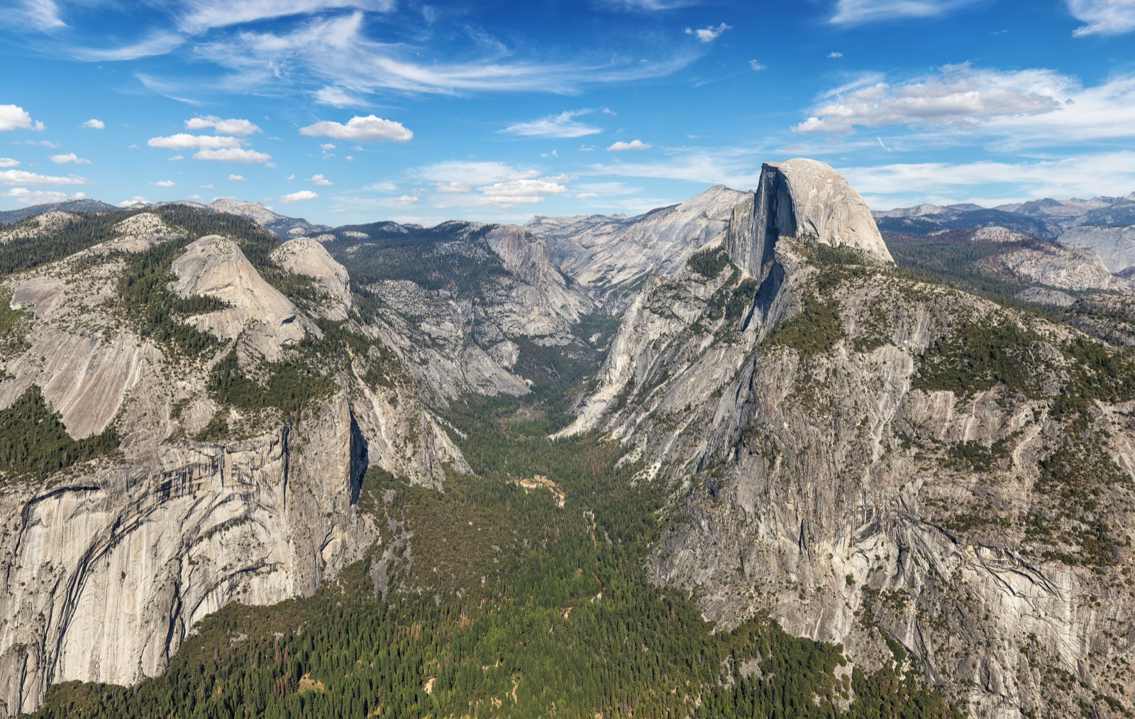
The classic Tunnel View panorama of Yosemite Valley, with El Capitan on the left, Bridalveil Fall on the right, and Half Dome rising in the distance.
The classic Tunnel View panorama of Yosemite Valley, with El Capitan on the left, Bridalveil Fall on the right, and Half Dome rising in the distance. David Iliff / Wikimedia Commons · CC BY-SA 3.0
03 Don't miss
  • El Capitan from Tunnel View
  • Yosemite Falls (tallest in North America)
  • Half Dome
  • Glacier Point
  • Mariposa Grove of Giant Sequoias
04 Getting there & truck/RV access
Route from interstate

From I-5

CA-120 east at Mossdale (Lathrop)

From I-5 take CA-120 east at Mossdale and stay on it through Manteca, Oakdale, and Groveland, about 95 mi to the Big Oak Flat Entrance and about 120 mi to Yosemite Valley

Big rigs & RVs

Truck access

Commercial trucking through Yosemite is prohibited. Park roads are closed to commercial vehicles whose trip has nothing to do with running the park, so CA-120 and CA-140 are not a shortcut for a loaded truck. Deliveries to the park and access to private land inside it move under a superintendent's permit. Every open road also caps length: 45 feet for a single vehicle on Big Oak Flat Road (CA-120 from the west) and Wawona Road (CA-41), and on El Portal Road (CA-140) 45 feet single, 60 feet combination, and 35 feet for a towed vehicle measured hitch to rear bumper. Outside the park, CA-140 between El Portal and Mariposa handles up to 45 feet, single or combined.

Parking: Parking for RVs, trailers, and other oversized vehicles is limited and can fill by late morning in summer, especially on weekends. In Yosemite Valley, larger class A and B rigs park at Curry Village or at Yosemite Falls parking, the lot west of Yosemite Valley Lodge across from Camp 4. Smaller class C RVs also fit the Yosemite Village day-use lot. Outside the valley there is limited RV parking at the Mariposa Grove Welcome Plaza, at Olmsted Point and Tuolumne Meadows on Tioga Road, and at Sentinel Dome and Glacier Point, where only RVs 30 feet and shorter go past Sentinel Dome. Sleeping in an RV outside a campground is not allowed. Fuel is at Wawona, Crane Flat, and El Portal, 24 hours with a credit card. There is none in Yosemite Valley and none at Tuolumne Meadows.

Restrictions: Glacier Point Road allows no vehicle over 30 feet and no trailers past the Sentinel Dome and Taft Point trailhead, and buses over 30 feet or seating 26 or more stop at Badger Pass. Mariposa Grove Road is capped at 21 feet with no trailers. Hetch Hetchy Road is capped at 25 feet long and 8 feet wide mirror to mirror, and it is open sunrise to sunset only. Wawona Tunnel on CA-41 clears 10 feet 2 inches at the curb into the valley and 13 feet 6 inches out of it, and the arch is higher at the fog line, so a California legal rig clears while staying in its lane. The Big Oak Flat Road tunnels clear 10 feet 3 inches at the curb from the valley and 13 feet 8 inches into it. The park sets its own kingpin to rear axle limits: 40 feet on Wawona Road and Tioga Road, 32 feet on El Portal Road, under 30 feet on Big Oak Flat Road. When the road base is saturated the park signs and enforces a 14,000 pound limit.

05 Seasonality & road closures

Best months: May to June for waterfalls at peak; September to October for clear weather and full road access without summer crowds.

Closures: Tioga Road (CA-120 east of Crane Flat) and Glacier Point Road close for snow around November. Plowing starts about April 15 and takes one to two months, and both usually reopen in late May or early June. From about mid December through March the first five miles of Glacier Point Road stay open to Badger Pass Ski Area.

Notes: Yosemite does not use a timed entry reservation system in 2026. The park announced on February 18, 2026 that it is managing busy days with real time traffic monitoring and active parking management instead. Entrance fees still apply.

06 Entrance fees (2026)
PassPrice
Private vehicle (7-day) $35
Motorcycle (7-day) $30
Individual / walk-in (7-day, age 16+) $20
Park-specific annual pass $70 (Yosemite Annual Pass)
America the Beautiful (annual, all NPS sites) $80 U.S. residents · $250 non-residents

2026 nonresident fee — applies at this park

Each non-U.S. resident aged 16 and older pays an additional $100 per person on top of the standard entrance fee. The fee is waived for visitors holding the $250 America the Beautiful Non-Resident Annual Pass (which also covers up to three additional adults). Children under 16 are exempt. U.S. residency is verified with a U.S. passport, U.S. driver's license / state ID, or Permanent Resident Card.

Fee-free days available for U.S. residents only beginning January 1, 2026.

Note: No entry reservation is required in 2026. The park dropped the timed entry system for the season on February 18, 2026.

Official NPS fee page →

07 Current alerts (17)

Active National Weather Service alerts and FEMA disaster declarations affecting Yosemite National Park's state(s). Alerts are read every 15 minutes and this page is rebuilt every 30 minutes.

COASTAL FLOOD WARNING

Coastal Flood Warning issued October 23 at 11:03AM PDT until October 29 at 1:00PM PDT by NWS San Diego CA

San Diego County Coastal Areas; Orange County Coastal

FREEZE WARNING

Freeze Warning issued October 23 at 10:43AM PDT until October 24 at 9:00AM PDT by NWS Eureka CA

Southern Trinity; Northwestern Interior Mendocino; Northeastern Interior Mendocino; Northern Lake; Northwestern and Central Trinity; Northeastern Trinity

SPECIAL WEATHER STATEMENT

Special Weather Statement issued October 23 at 3:41PM PDT by NWS Hanford CA

Bakersfield; Southeast San Joaquin Valley; South End San Joaquin Valley; South End Sierra Foothills; Kern River Valley; Piute Walker Basin

LAKE WIND ADVISORY

Lake Wind Advisory issued October 23 at 11:49AM PDT until October 24 at 8:00AM PDT by NWS Reno NV

Greater Lake Tahoe Area; Greater Lake Tahoe Area

WIND ADVISORY

Wind Advisory issued October 23 at 10:51AM PDT until October 24 at 11:00AM PDT by NWS Las Vegas NV

Death Valley National Park

FLOOD ADVISORY

Flood Advisory issued October 23 at 3:14PM PDT until October 23 at 5:15PM PDT by NWS Hanford CA

Kern, CA

COASTAL FLOOD ADVISORY

Coastal Flood Advisory issued October 23 at 12:45PM PDT until October 29 at 3:00PM PDT by NWS San Francisco CA

San Francisco; North Bay Interior Valleys; San Francisco Bay Shoreline; Northern Monterey Bay; Southern Monterey Bay and Big Sur Coast

COASTAL FLOOD ADVISORY

Coastal Flood Advisory issued October 23 at 12:45PM PDT until October 29 at 3:00PM PDT by NWS San Francisco CA

Coastal North Bay Including Point Reyes National Seashore; San Francisco Peninsula Coast

FEMA · Fire CA

NORTE FIRE

Orange (County)

FEMA · Fire CA

GANN FIRE

Calaveras (County)

FEMA · Fire CA

DOVE FIRE

Tuolumne (County)

FEMA · Fire CA

BAIN FIRE

Riverside (County)

FEMA · Fire CA

SANDY FIRE

Ventura (County)

08 FAQ
What's the best route from I-5 to Yosemite?
From I-5 take CA-120 east at Mossdale and stay on it through Manteca, Oakdale, and Groveland to the Big Oak Flat Entrance, about 95 miles. From the Bay Area the same road is I-580 east to I-205 east to CA-120 east. CA-140 through Merced and Mariposa is longer and lower, and the park says chains are needed there less often than on CA-120 west or CA-41. Neither route works for a commercial load, because trucking through Yosemite is prohibited.
Is Tioga Road open year-round?
No. Tioga Road (CA-120 east of Crane Flat) closes for snow around November and usually reopens in late May or early June. Plowing starts on or about April 15 and takes one to two months. The park does not forecast the date, its own page says predicting the opening is not possible even in late spring, so watch the plowing update page for the announcement.
How much is Yosemite entry in 2026?
$35 per private vehicle for a 7-day pass. The America the Beautiful pass is $80 for U.S. residents, $250 for non-residents. Beginning January 1, 2026, each non-U.S. resident aged 16+ pays an additional $100 nonresident fee unless they hold the $250 non-resident annual pass.
Do I need a reservation to enter Yosemite?
No. On February 18, 2026 the park announced it will not use a timed entry reservation system this year. Busy days are handled with real time traffic monitoring, active parking management in the valley, and extra staff at key intersections. You still pay the entrance fee, and weekdays are the easiest time to find parking.

Yosemite National Park on the live map

See real-time weather alerts, wildfires, and road incidents around the park before you head out.

Open Live Map