← All National Parks
National Park No. UT No nonresident surcharge

Capitol Reef National Park

Capitol Reef is the least-visited of Utah's "Mighty 5" parks, a 100-mile monocline (warp in the earth's crust) called the Waterpocket Fold that creates a natural barrier through south-central Utah. Within it lies the Fremont River valley, where 19th-century Mormon pioneers establ…

I-70Nearest Interstate
1State
4FAQ
2Active Alerts
01 Park overview

Capitol Reef is the least-visited of Utah's "Mighty 5" parks, a 100-mile monocline (warp in the earth's crust) called the Waterpocket Fold that creates a natural barrier through south-central Utah. Within it lies the Fremont River valley, where 19th-century Mormon pioneers established the orchard town of Fruita; the historic orchards are still maintained by NPS, and visitors can pick fruit in season ($2/pound). The signature Scenic Drive runs 8 miles south from the visitor center past Capitol Dome and into Capitol Gorge. Cathedral Valley (north) and the Waterpocket Fold (south) are the wilder, unpaved districts. From I-70 the closest access is Exit 149 (UT-24 / Hanksville turnoff), then 75 mi west on UT-24 along the Fremont River to the visitor center.

  • One of Utah's "Mighty 5" parks (with Zion, Bryce Canyon, Arches, and Canyonlands)
  • Protects the Waterpocket Fold, a 100-mile-long monocline in the earth's crust
  • Historic Fruita orchards still in production, visitors can pick fruit ($2/lb) in season
  • ~1.4 million visitors per year, least-crowded of Utah's national parks
  • Designated an International Dark Sky Park (Gold Tier, 2015)
02 Photos
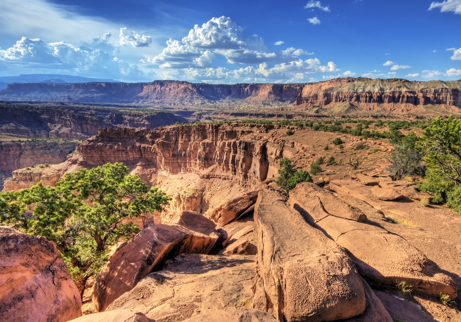
A wide panorama looking north and east from the Castle overlook, showing the colorful eroded cliffs and rock formations of Capitol Reef National Park, Utah.
A wide panorama looking north and east from the Castle overlook, showing the colorful eroded cliffs and rock formations of Capitol Reef National Park, Utah. Famartin / Wikimedia Commons · CC BY-SA 3.0
03 Don't miss
  • Scenic Drive (8-mile paved)
  • Capitol Gorge wash hike
  • Hickman Bridge Trail
  • Cathedral Valley loop (high-clearance 4WD)
  • Fruita orchards in fruit-picking season (June to October, varies by crop)
04 Getting there & truck/RV access
Route from interstate

From I-70

Exit 149 (UT-24 / Hanksville)

75 mi west on UT-24 to the visitor center near Fruita

Big rigs & RVs

Truck access

UT-24 along the Fremont River through the park is paved and unrestricted for any vehicle size. The 8-mile Scenic Drive is paved and accommodates RVs but the final two miles narrow into Capitol Gorge.

Parking: Visitor center and Scenic Drive overlook lots are RV-capable. Truck-friendly fuel is at Hanksville (I-70 / UT-24 junction) and Torrey, UT (10 mi west of the park). No commercial fuel inside the park.

Restrictions: Cathedral Valley Loop and Notom-Bullfrog Road (south district) are unpaved high-clearance routes, RVs and trailers prohibited. The Scenic Drive's last two miles into Capitol Gorge restrict vehicles over 27 ft.

05 Seasonality & road closures

Best months: April to May and September to October, comfortable temperatures, low flash-flood risk on side trails.

Closures: No seasonal road closures on UT-24 or the main Scenic Drive. Cathedral Valley loops and slot-canyon routes close after rain. Fruit-picking season runs roughly June (cherries) through October (apples) by crop.

Notes: Summer afternoon thunderstorms cause flash floods in narrow canyons (Capitol Gorge, Grand Wash), check daily forecasts before any wash hike.

06 Entrance fees (2026)
PassPrice
Private vehicle (7-day) $20
Motorcycle (7-day) $15
Individual / walk-in (7-day, age 16+) $10
Park-specific annual pass $35 (Capitol Reef Annual Pass)
America the Beautiful (annual, all NPS sites) $80 U.S. residents · $250 non-residents

2026 nonresident fee — does not apply here

The $100 NPS nonresident surcharge applies at 11 specifically named parks. Capitol Reef National Park is not on that list, so non-U.S. residents pay the same standard entrance fees as U.S. residents.

Fee-free days available for U.S. residents only beginning January 1, 2026.

Note: Entrance fee is collected only on the Scenic Drive, UT-24 through the park (the main thoroughfare) is free to drive.

Official NPS fee page →

07 Current alerts (2)

Active National Weather Service alerts and FEMA disaster declarations affecting Capitol Reef National Park's state(s). Updated every 15 minutes.

HEAT ADVISORY

Heat Advisory issued July 25 at 12:38AM MDT until July 28 at 12:00AM MDT by NWS Salt Lake City UT

Cache Valley/Utah Portion

HEAT ADVISORY

Heat Advisory issued July 25 at 12:38AM MDT until July 28 at 12:00AM MDT by NWS Salt Lake City UT

Eastern Box Elder County; Northern Wasatch Front; Salt Lake Valley; Utah Valley

08 FAQ
How do I get to Capitol Reef from I-70?
75 miles west of I-70 Exit 149 on UT-24 (the Fremont River corridor). The drive takes about 90 minutes through Hanksville and runs along the river to the visitor center near Fruita.
Do I have to pay an entrance fee just to drive through?
No. UT-24 (the main highway through the park) is free. The $20 vehicle fee is only collected on the 8-mile Scenic Drive south of the visitor center.
Does the $100 nonresident fee apply?
No. Capitol Reef is not on the 2026 NPS nonresident-surcharge list. The standard $20 vehicle fee applies to all visitors when on the Scenic Drive.
Can I really pick fruit in the orchards?
Yes. NPS maintains roughly 1,900 historic fruit trees in Fruita. Self-pick is $2/pound (cash or credit at on-site self-pay stations) and runs roughly June (cherries) through October (apples). Specific crops are posted at the visitor center.

Capitol Reef National Park on the live map

See real-time weather alerts, wildfires, and road incidents around the park before you head out.

Open Live Map