← All Interstates
Interstate No. 95 209 live incidents

I-95: The Atlantic Seaboard

Interstate 95 is the principal north-south interstate of the Eastern Seaboard, running 1,919 miles from Miami, Florida to Houlton, Maine at the Canadian border. It serves every major Atlantic Coast metropolitan area: Miami, Jacksonville, Savannah, Charleston, Wilmington, Richmond…

209Incidents
3Alerts in its states
16States
5Hazards
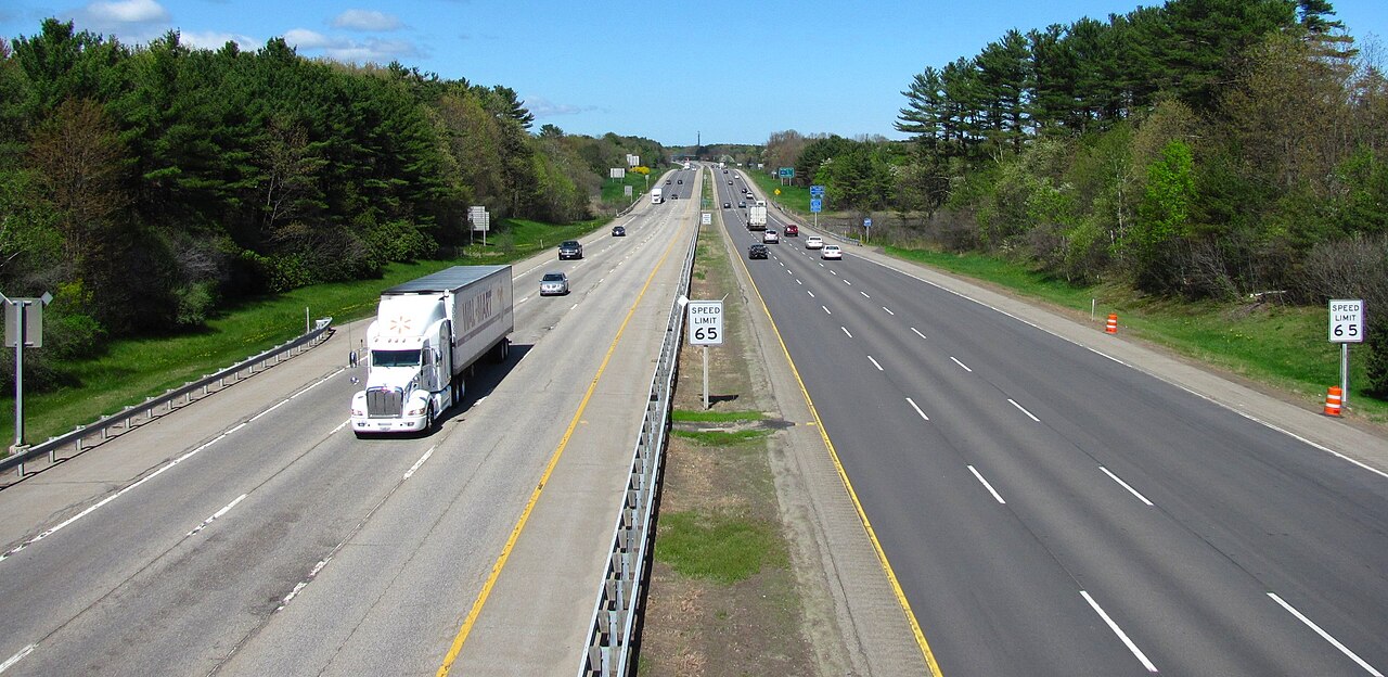
I-95 northbound near Kittery, Maine
I-95 northbound near Kittery, Maine John Phelan (Wikimedia user Faolin42) / Wikimedia Commons · CC BY 3.0
01 Route overview

Interstate 95 is the principal north-south interstate of the Eastern Seaboard, running 1,919 miles from Miami, Florida to Houlton, Maine at the Canadian border. It serves every major Atlantic Coast metropolitan area: Miami, Jacksonville, Savannah, Charleston, Wilmington, Richmond, Washington DC, Baltimore, Philadelphia, New York, Hartford, Providence, Boston, and Portland. It is consistently the most traveled interstate in the country.

For freight, I-95 carries most of the East Coast's truck traffic. Container traffic from the ports of Miami, Savannah, Charleston, Norfolk, New York/New Jersey, and Boston all moves on I-95 at some point. The I-95 and SR 4 interchange near the George Washington Bridge in Fort Lee, New Jersey ranked the worst truck bottleneck in the country for the seventh year running (ATRI 2025). The wider Northeast Corridor between Washington DC and Boston carries heavy commuter and freight traffic and is heavily tolled, so expect chronic peak-hour backups through the metro areas. Virtually every mile from Delaware north has tolls or is part of a tolled bridge or tunnel.

Geographically I-95 is almost entirely a flat coastal-plain interstate, with the only meaningful elevation changes through the rolling Piedmont of Virginia and the Appalachian foothills in Maine. Weather hazards are dominated by hurricanes (the corridor is the principal evacuation route for the Atlantic Coast), nor'easters that cause winter closures from New York north, and chronic congestion-related incidents.

  • Longest north-south interstate: about 1,917 miles, Maine to Florida through 15 states (FHWA)
  • Crosses sixteen states + DC: FL, GA, SC, NC, VA, DC, MD, DE, PA, NJ, NY, CT, RI, MA, NH, ME
  • Connects every major Atlantic Coast metro area
  • Heavily tolled north of Delaware: virtually every mile has tolls or is on a tolled crossing
  • Designated hurricane evacuation route for the entire Atlantic Coast
  • Includes the Fort McHenry Tunnel (Baltimore) and the George Washington Bridge approach (NJ/NY)
  • Northern terminus is the Houlton, ME border crossing into New Brunswick
02 Key cities & junctions
StateMileCity / Junction
FL MM 1 Miami
FL MM 105 Fort Pierce
FL MM 261 Daytona Beach
FL MM 333 Jacksonville (I-10 jct)
GA MM 67 Brunswick
GA MM 103 Savannah (I-16 jct)
SC MM 33 Hilton Head / Hardeeville
SC MM 86 Walterboro
SC MM 169 Florence (I-20 jct)
NC MM 1 Lumberton
NC MM 87 Fayetteville
NC MM 173 Smithfield (I-40 access)
VA MM 13 Emporia
VA MM 84 Richmond (I-64/I-85/I-295 jct)
VA MM 130 Fredericksburg
VA MM 160 Springfield (I-495 jct)
DC MM 0 Washington DC (I-495 Beltway)
MD MM 27 Baltimore (Fort McHenry Tunnel)
DE MM 1 Newark
PA MM 1 Marcus Hook
PA MM 22 Philadelphia (I-76/I-676 jct)
NJ MM 1 Trenton (NJ Turnpike concurrency)
NJ MM 113 Newark (NJ Turnpike)
NY MM 1 Bronx (Cross Bronx Expressway)
NY MM 16 New Rochelle
CT MM 7 Greenwich
CT MM 50 New Haven (I-91 jct)
RI MM 13 Providence
MA MM 18 Boston (I-93 jct)
NH MM 1 Salisbury / Seabrook
ME MM 1 Kittery
ME MM 44 Portland
ME MM 209 Bangor (I-395 jct)
ME MM 303 Houlton / Canadian Border
04 Notable hazards & trouble spots
Hazard

Heaviest truck traffic on the corridor + dual roadways

New Jersey Turnpike (MM 1-118)

The NJ Turnpike (which carries I-95) splits into separate inner (car) and outer (truck/bus/RV) roadways for much of its length. Trucks must use the outer roadway. Tolls are heavy, and northern New Jersey is the worst truck-congestion stretch on I-95: the I-95/SR 4 interchange in Fort Lee held the #1 spot on ATRI's national truck-bottleneck list for the seventh straight year (ATRI 2025). The Newark-Elizabeth area around the port and Newark Airport stays heavily congested through the day.

Hazard

Home to the nation's #1 truck bottleneck (I-95/SR 4, Fort Lee NJ; ATRI 2025)

Cross Bronx Expressway, NY (MM 1-9)

Plan for stop-and-go truck speeds across the Cross Bronx during peak hours; across ATRI's ten worst bottlenecks nationally, rush-hour truck speeds averaged 29.7 mph (ATRI 2025). There is no practical alternate. The George Washington Bridge approach can take 2+ hours during peak periods.

Hazard

HAZMAT-restricted tunnel with toll

Fort McHenry Tunnel, Baltimore, MD (MM 27)

I-95 crosses Baltimore Harbor through the Fort McHenry Tunnel. Placarded HAZMAT loads are prohibited. The required detour is the I-695 Francis Scott Key Bridge, which itself collapsed in 2024, so the long-term detour adds significant time. Check MDTA bulletins.

Hazard

Long stretches of heavy urban congestion (FHWA)

I-95 / I-495 Capital Beltway, MD/VA (MM 160 VA - 27 MD)

The Capital Beltway segment from Springfield, VA through Washington DC and into Maryland runs heavily congested; over 60 percent of I-95's roughly 1,040 urban miles are under heavy congestion (FHWA). Express toll lanes (I-495 Express, I-95 Express) operate but are restricted from heavy commercial vehicles in some segments.

Hazard

Mandatory northbound contraflow during evacuations

Hurricane evacuation contraflow (MM 1 FL - 169 SC)

When a major hurricane threatens the Southeast Coast, Florida, Georgia, and South Carolina reverse the southbound lanes to send all traffic north. Trucks face hours-long delays and may be ordered off the road entirely. Monitor 511 Florida, GDOT, and SCDOT.

05 Active incidents (209)
CLOSURE NC

closures

I-95 Southbound

CLOSURE NC

closures

I-95

CLOSURE NC

The South Weigh Station will be closed.

I-95

CLOSURE MD

Active Closure @ I-95 NORTH AT FORT MCHENRY TUNNEL BORE 3

I-95 NORTH

CLOSURE MD

Active Closure @ I-95 SOUTH PAST EXIT 50A-B US 1 CATON AVE (SB) (MM 50.2 - 50.0) LONG TERM CONTINUOUS

I-95 SOUTH

CLOSURE MD

Active Closure @ I-95 SOUTH AT FORT MCHENRY TUNNEL BORE 2

I-95 SOUTH

ACCIDENT SC

Crash

I-95

CONSTRUCTION ME

Other on I 95

I 95

CONSTRUCTION ME

Construction on I 95

I 95

CONSTRUCTION ME

Construction on I 95 SB

I 95 SB

CONSTRUCTION ME

Construction on I 95 SB

I 95 SB

CONSTRUCTION ME

Construction on I 95

I 95

CONSTRUCTION ME

Construction on I 95 SB

I 95 SB

CONSTRUCTION ME

Construction on I 95

I 95

CONSTRUCTION FL

I95 NB to 441 NB detour

I 95

CONSTRUCTION FL

I95 NB to 441 NB detour

I 95

CONSTRUCTION FL

I-95 over US-1 Interchange

I 95

CONSTRUCTION SC

construction work

I-95

Showing 18 of 209. View all on map →

06 Weather alerts in its states (3)

National Weather Service alerts in force in the states Interstate 95 runs through. Each one covers a county or a forecast zone, which may be far from the Interstate.

  • 3 alerts in Florida: Coastal Flood Advisory, Flood Watch

See where each alert is on the live map →

07 FAQ
How long does it take to drive I-95 end to end?
A passenger car can cover the 1,919 miles in 30-34 hours of driving time. Commercial drivers respecting hours-of-service rules typically need 4 to 5 days, with chronic delays through the Northeast Corridor between Washington DC and Boston.
Is I-95 a toll road?
Mostly north of Delaware. I-95 includes tolls on the Delaware Turnpike, Pennsylvania Turnpike concurrency segments, Delaware Memorial Bridge, NJ Turnpike, George Washington Bridge, Connecticut tolls (limited), and the Maine Turnpike. The Florida, Georgia, South Carolina, North Carolina, and Virginia segments are toll-free.
Does I-95 close in winter?
Yes. Nor'easters and major winter storms regularly close segments from New York through Maine for plowing. The southern segments (Florida through Virginia) rarely close for snow but can be closed for hurricane evacuations or flooding. Check 511 systems for each state.
What is the busiest section of I-95?
The New Jersey Turnpike segment between Exit 8A (Cranbury) and the George Washington Bridge carries very high volumes; FHWA reports peak daily traffic above 300,000 vehicles and peak daily truck traffic above 31,000, a truck share of about 10 percent rather than 15. The Cross Bronx Expressway is the most congested segment by speed.
Are HAZMAT loads allowed on I-95 through Baltimore?
No, not through the Fort McHenry Tunnel. Placarded HAZMAT loads must use I-695 (the Baltimore Beltway). Following the 2024 collapse of the Francis Scott Key Bridge on I-695, HAZMAT routing has been more complicated. Check MDTA bulletins for current requirements.

Interstate 95 Live Map

See every incident, alert, and road condition on Interstate 95 in real time.

Open Live Map