Is I-74 closed right now?
Our state DOT feeds show no closures of I-74 itself as of . Indiana reports 1 closed ramp on I-74, listed below. A closure the feeds have not reported will not show here.
Our state DOT feeds show no closures of I-74 itself as of . Indiana reports 1 closed ramp on I-74, listed below. A closure the feeds have not reported will not show here.
Our feeds show no closures, crashes or work zones on I-74 in Iowa.
Iowa road conditions →Our feed shows 6 temporary restrictions for oversize loads on I-74 in Illinois.
Illinois road conditions →Our feeds show 0 closures, 1 closed ramp, 0 crashes and 9 work zones on I-74 in Indiana.
Our feeds show no closures, crashes or work zones on I-74 in Ohio.
Ohio road conditions →Our feeds show no closures, crashes or work zones on I-74 in North Carolina.
North Carolina road conditions →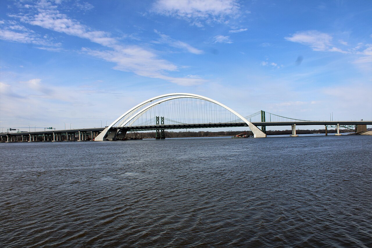
Interstate 74 is an unusual interstate: it consists of two non-contiguous segments. The western segment runs 419 miles from Davenport, Iowa (the Quad Cities) southeast to Cincinnati, Ohio, crossing Illinois and Indiana. A separate eastern segment is in central North Carolina, but the two segments are not yet connected. Most freight traffic on I-74 uses the western segment.
For freight, the western I-74 ties the Quad Cities intermodal hubs to the Indianapolis ring road and the Cincinnati metro. It is the main corridor for John Deere and Caterpillar parts moving between manufacturing facilities, and it serves the agricultural belt of central Illinois and Indiana.
Geographically I-74 is mostly flat, crossing the prairie and rolling country of central Illinois and Indiana. Weather hazards are dominated by Midwest severe storms in spring, ground blizzards in winter across the open prairie segments, and the occasional ice event in the Indiana hills.
| State | Mile | City / Junction |
|---|---|---|
| IA | MM 0 | Davenport / Quad Cities (I-80 jct) |
| IL | MM 4 | Moline |
| IL | MM 35 | Galesburg |
| IL | MM 90 | Peoria (I-474 jct) |
| IL | MM 135 | Bloomington-Normal (I-39/I-55 jct) |
| IL | MM 188 | Champaign-Urbana (I-57 jct) |
| IL | MM 220 | Danville |
| IN | MM 8 | Crawfordsville |
| IN | MM 73 | Indianapolis (I-465 jct) |
| IN | MM 135 | Greensburg |
| IN | MM 168 | Batesville |
| OH | MM 1 | Cincinnati (I-275 jct) |
Central Illinois prairie (MM 35-220)
The 200-mile stretch across central Illinois is flat and exposed. Ground blizzards with zero-visibility whiteouts can develop in minutes. IDOT closes I-74 segments multiple times each winter for blowing snow.
Quad Cities Mississippi River bridge (MM 0)
The I-74 Mississippi River bridges between Bettendorf, IA and Moline, IL were replaced with new spans in 2021. The new bridges provide more capacity but remain a chokepoint during incidents. The alternates are I-80 (Le Claire) or US-67 (Davenport).
Indianapolis I-465 outerbelt (MM 73)
I-74 through Indianapolis intersects I-465. INDOT prefers through-truck routing on I-465 over the inner urban segments. HAZMAT routing requirements apply.
Spring severe weather (MM 35-220)
Central Illinois and Indiana sit on the northern edge of Tornado Alley. Severe spring storms with damaging hail and tornadoes are routine April through June. Park under solid shelter when warnings are active.
Cincinnati I-74 / I-275 terminus (MM 1 OH)
I-74 ends at I-275 just outside Cincinnati. The interchange is busy with commuter and truck traffic; through trucks generally route via I-275 to I-71 / I-75 rather than the inner urban segments.
I-74 in both directions (Mile Point 112.83 - 123.19): Bridge construction between IN 9 and County Line Rd.
I-74
I-74 (Mile Point 111.43 - 123.19): Road construction between Michigan Rd and County Line Rd.
I-74
I-74 eastbound (Mile Point 112 - 117.5): Roadwork between Michigan Rd and IN 244.
I-74
I-74 westbound (Mile Point 130 - 133.9): Roadwork between IN 3 and N 420 W in Greensburg.
I-74
I-74 eastbound (Mile Point 128 - 134): Road maintenance operations between W 750 N and E North Rd.
I-74
I-74 in both directions (Mile Point 169.05 - 169.42): Alternating lane closures between US 52 and US 52.
I-74
I-74 eastbound: Exit 116F ramp to IN 44 blocked.
I-74
I-74 westbound (Mile Point 118 - 123.6): Roadwork between W 750 N and Blue Ridge Rd.
I-74
I-74 eastbound (Mile Point 118 - 123): Roadwork between Blue Ridge Rd and County Line Rd.
I-74
I-74 in both directions (Mile Point 169): Alternating lane closures between Longnecker Rd and US 52 near Brigh…
I-74
I-74 eastbound (Mile Point 128.4 - 128.41): Height limit in effect between N 420 W and US 421; OLD US 421.
I-74
I-74 (Mile Point 93.59 - 94.05): Ramp restrictions in force between OLD US 421; I-465; Southeastern Ave and Fi…
I-74
I-74 eastbound (Mile Point 127.3 - 133.6): Width limit in effect between W 750 N and IN 3.
I-74
Temporary Restriction: 12-06 MAX WIDTH - BLOOMINGTON-MP 135 TO MP 143
I-74
Temporary Restriction: 13-06 MAX WIDTH - OAKWOOD-MP 202 TO MP 203
I-74
Temporary Restriction: 12-06 MAX WIDTH - WOODHULL-MP 31 TO MP 33
I-74
Temporary Restriction: 12-06 MAX WIDTH - PEORIA-EB RAMP TO INT474/MP 1
I-74
Temporary Restriction: 15-06 MAX WIDTH - BRIMFIELD-MP 73 TO MP 74
I-74
Showing 18 of 20. View all on map →
National Weather Service alerts in force in the states Interstate 74 runs through. Each one covers a county or a forecast zone, which may be far from the Interstate.
See every incident, alert, and road condition on Interstate 74 in real time.
Open Live Map